What is the difference between an Ellipsoid and a Geoid and how does it pertain to drones?
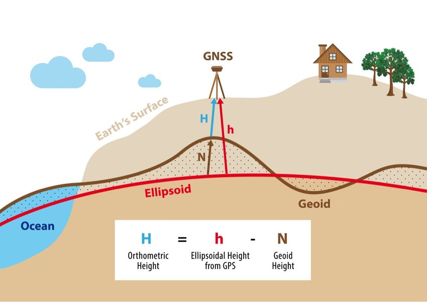
December 21, 2023In simple terms, the geoid and the ellipsoid are two different models used in geography and surveying to describe the shape of the Earth.
GEOID:
Imagine if the Earth’s surface were completely covered by water, and this water formed a surface that was shaped by the gravitational pull of the Earth and the irregularities in its mass (like mountains and valleys). The shape of this “water surface” would be the geoid. It’s essentially the shape of the Earth’s surface if there were no land masses and only the force of gravity determined its shape. The geoid represents what the surface of the Earth would look like if it were entirely covered by a smooth and continuous ocean.
ELLIPSOID:
The ellipsoid is a simplified mathematical model of the Earth’s shape. It’s like taking the Earth and imagining it as a perfect, smooth sphere that is slightly flattened at the poles and bulging at the equator. In other words, it’s like an Earth-shaped ball that’s not quite round but more like an oval. This shape is easier to work with mathematically, which is why it’s often used for calculations and mapping.
In summary, the geoid represents the actual, irregular shape of the Earth’s surface, taking into account the influence of gravity and the Earth’s mass distribution. The ellipsoid, on the other hand, is a simplified, smoother shape that makes mathematical calculations and mapping tasks easier. Surveyors and geographers use both models depending on their specific needs and the level of accuracy required for their work.
SO HOW DOES THIS PERTAIN TO DRONE MAPPING AND SURVEYING?
Drones equipped with surveying and mapping instruments often need to provide real-world, “on-the-ground” measurements. Since the Earth’s surface is not perfectly smooth or spherical due to variations in gravity and the shape of the land, the geoid is used as a reference for vertical datums. This means that elevations or heights measured by drones are typically referenced to the geoid.
For example, when a drone is used to create digital elevation models (DEMs) or topographic maps, it measures the height of various points on the Earth’s surface above or below the geoid. This helps ensure that elevation data collected by drones corresponds to the actual shape of the Earth and can be used for various applications like flood modeling, construction planning, and land surveying.
While the geoid is essential for accurate height measurements, the ellipsoid is often used as a reference for horizontal datums and for simplifying calculations in aerial surveying. The Earth’s shape is approximated as an ellipsoid, and this ellipsoidal model is used in coordinate systems and map projections. When drones collect data for horizontal positioning (latitude and longitude), they typically use coordinates referenced to the ellipsoid. This simplifies the mathematics involved in calculating distances, areas, and angles on maps. Many mapping software and GPS systems use ellipsoidal coordinates to ensure compatibility and consistency in spatial data.
IN SUMMARY:
in drone surveying and mapping, the geoid is primarily used for accurate height measurements, while the ellipsoid is used for horizontal positioning and simplifying calculations. These two reference models work together to ensure that the data collected by drones accurately represents the Earth’s three-dimensional surface, making it valuable for a wide range of applications in geography, land surveying, and remote sensing.
